campingssans voiture

VOTRE POINT DE DÉPART POUR DÉCONNECTER

Camping la Vallée de l’Indre

Montbazon · Indre-et-Loire · Camping 3 étoiles

À MA PORTÉE

Votre séjour sans voiture.

Selon vos critères · 800 m avec bagages · 1,5 km sans bagages · bus direct

POSER SES VALISES

Le temps de vivre dehors.

Marche courte, avec un point à anticiper. Un arrêt à courte marche. Une gare voyageurs recensée. Le jour de retour fait la différence. Le dimanche est à vérifier. Aucun départ à venir relevé dans les horaires publiés le dimanche 15 novembre 2026. Arrêt La Courtille à 440 m (7 min à pied), gare de Montbazon à 710 m.

Camping 3 étoiles104 emplacements

Classement Atout France du 27/10/2021.

01 · VENIR AU CAMPING

Depuis chez vous, à vos dates.

Venir depuis chez vous

Votre trajet complet jusqu’au camping, à vos dates — depuis une adresse, une ville ou une gare.

02 · VIVRE AU QUOTIDIEN

L’essentiel, autour de vous.

3/3 besoins faciles

Au moins une adresse facile pour chaque besoin choisi. Ouvrez une catégorie pour comparer les lieux et leurs trajets.

Courses10 faciles / 75Facile
9 min à pied · 568 m de marche
Facile
10 min à pied · 691 m de marche
Facile
10 min à pied · 690 m de marche
Facile
11 min à pied · 706 m de marche
Facile
11 min à pied · 720 m de marche
Facile
11 min à pied · 715 m de marche
Facile
16 min à pied · 1 km de marche
Facile
20 min · bus direct · 840 m de marche · ou 86 min à pied · 5,7 km
Facile
21 min · bus direct · 880 m de marche · ou 89 min à pied · 6 km
Facile
24 min · bus direct · 1,1 km de marche · ou 92 min à pied · 6,2 km
Facile
28 min à pied · 1,9 km de marche
Moyen
32 min à pied · 2,1 km de marche
Moyen
32 min à pied · 2,1 km de marche
Moyen
32 min à pied · 2,1 km de marche
Moyen
33 min à pied · 2,2 km de marche
Moyen
33 min à pied · 2,2 km de marche
Moyen
47 min · bus direct · 2,4 km de marche · ou 147 min à pied · 9,8 km
Moyen
48 min · bus direct · 1,9 km de marche · ou 88 min à pied · 5,8 km
Moyen
49 min · bus direct · 2,4 km de marche · ou 95 min à pied · 6,3 km
Moyen
51 min · bus direct · 2,7 km de marche · ou 145 min à pied · 9,7 km
Moyen
51 min · bus direct · 2,4 km de marche · ou 137 min à pied · 9,1 km
Moyen
52 min · bus direct · 2,8 km de marche · ou 75 min à pied · 5 km
Moyen
53 min · bus direct · 2,6 km de marche · ou 95 min à pied · 6,3 km
Moyen
53 min · bus direct · 2,6 km de marche · ou 95 min à pied · 6,3 km
Moyen
53 min · bus direct · 2,5 km de marche · ou 157 min à pied · 10,5 km
Moyen
54 min · bus direct · 2,6 km de marche · ou 89 min à pied · 5,9 km
Moyen
54 min · bus direct · 2,7 km de marche · ou 89 min à pied · 6 km
Moyen
54 min · bus direct · 2,6 km de marche · ou 94 min à pied · 6,3 km
Moyen
54 min · bus direct · 2,9 km de marche · ou 156 min à pied · 10,4 km
Moyen
54 min · bus direct · 2,5 km de marche · ou 153 min à pied · 10,2 km
Moyen
54 min · bus direct · 2,5 km de marche · ou 153 min à pied · 10,2 km
Moyen
54 min · bus direct · 2,5 km de marche · ou 157 min à pied · 10,5 km
Moyen
55 min · bus direct · 2,7 km de marche · ou 97 min à pied · 6,5 km
Moyen
55 min · bus direct · 2,6 km de marche · ou 145 min à pied · 9,6 km
Moyen
55 min · bus direct · 2,6 km de marche · ou 152 min à pied · 10,1 km
Moyen
55 min · bus direct · 2,6 km de marche · ou 152 min à pied · 10,1 km
Moyen
55 min · bus direct · 2,6 km de marche · ou 160 min à pied · 10,6 km
Moyen
56 min · bus direct · 2,8 km de marche · ou 90 min à pied · 6 km
Moyen
56 min · bus direct · 2,8 km de marche · ou 99 min à pied · 6,6 km
Moyen
56 min · bus direct · 2,7 km de marche · ou 152 min à pied · 10,1 km
Moyen
56 min · bus direct · 2,7 km de marche · ou 152 min à pied · 10,1 km
Moyen
57 min · bus direct · 2,7 km de marche · ou 115 min à pied · 7,7 km
Moyen
57 min · bus direct · 2,8 km de marche · ou 150 min à pied · 10 km
Moyen
57 min · bus direct · 2,8 km de marche · ou 150 min à pied · 10 km
Moyen
58 min · bus direct · 2,9 km de marche · ou 101 min à pied · 6,7 km
Moyen
58 min · bus direct · 2,8 km de marche · ou 150 min à pied · 10 km
Moyen
60 min · bus direct · 2,7 km de marche · ou 123 min à pied · 8,2 km
Moyen
63 min · bus direct · 2,7 km de marche · ou 131 min à pied · 8,7 km
Moyen
69 min · bus direct · 3 km de marche · ou 135 min à pied · 9 km
Moyen
52 min à pied · 3,5 km de marche
Difficile
56 min · bus direct · 3,2 km de marche · ou 120 min à pied · 8 km
Difficile
58 min · bus direct · 3,2 km de marche · ou 147 min à pied · 9,8 km
Difficile
58 min · bus direct · 3,2 km de marche · ou 147 min à pied · 9,8 km
Difficile
59 min · bus direct · 3,5 km de marche · ou 123 min à pied · 8,2 km
Difficile
59 min · bus direct · 3,2 km de marche · ou 149 min à pied · 9,9 km
Difficile
60 min · bus direct · 3 km de marche · ou 94 min à pied · 6,3 km
Difficile
60 min · bus direct · 3,1 km de marche · ou 103 min à pied · 6,8 km
Difficile
60 min · bus direct · 3,3 km de marche · ou 150 min à pied · 10 km
Difficile
62 min · bus direct · 3,6 km de marche · ou 126 min à pied · 8,4 km
Difficile
62 min · bus direct · 3,4 km de marche · ou 166 min à pied · 11,1 km
Difficile
63 min · bus direct · 3,3 km de marche · ou 97 min à pied · 6,5 km
Difficile
66 min · bus direct · 3,4 km de marche · ou 101 min à pied · 6,7 km
Difficile
67 min · bus direct · 3,5 km de marche · ou 102 min à pied · 6,8 km
Difficile
68 min · bus direct · 3,8 km de marche · ou 91 min à pied · 6 km
Difficile
68 min · bus direct · 3,5 km de marche · ou 130 min à pied · 8,7 km
Difficile
69 min · bus direct · 3,9 km de marche · ou 173 min à pied · 11,5 km
Difficile
70 min · bus direct · 3,6 km de marche · ou 131 min à pied · 8,7 km
Difficile
70 min · bus direct · 3,9 km de marche · ou 174 min à pied · 11,6 km
Difficile
72 min · bus direct · 3,9 km de marche · ou 105 min à pied · 7 km
Difficile
76 min · bus direct · 4,3 km de marche · ou 118 min à pied · 7,9 km
Difficile
83 min · bus direct · 4,6 km de marche · ou 115 min à pied · 7,7 km
Difficile
84 min · bus direct · 4,4 km de marche · ou 126 min à pied · 8,4 km
Difficile
85 min · bus direct · 5 km de marche · ou 108 min à pied · 7,2 km
Difficile
108 min à pied · 7,2 km de marche
Difficile
111 min à pied · 7,4 km de marche
Difficile
Pharmacie3 faciles / 26Facile
9 min à pied · 618 m de marche
Facile
21 min · bus direct · 900 m de marche · ou 90 min à pied · 6 km
Facile
27 min · bus direct · 1,3 km de marche · ou 92 min à pied · 6,1 km
Facile
25 min à pied · 1,7 km de marche
Moyen
31 min à pied · 2,1 km de marche
Moyen
49 min · bus direct · 2 km de marche · ou 88 min à pied · 5,8 km
Moyen
53 min · bus direct · 2,5 km de marche · ou 157 min à pied · 10,5 km
Moyen
54 min · bus direct · 2,9 km de marche · ou 155 min à pied · 10,3 km
Moyen
54 min · bus direct · 2,5 km de marche · ou 153 min à pied · 10,2 km
Moyen
55 min · bus direct · 2,7 km de marche · ou 95 min à pied · 6,3 km
Moyen
56 min · bus direct · 2,6 km de marche · ou 113 min à pied · 7,5 km
Moyen
57 min · bus direct · 2,7 km de marche · ou 149 min à pied · 9,9 km
Moyen
58 min · bus direct · 2,8 km de marche · ou 160 min à pied · 10,7 km
Moyen
59 min · bus direct · 2,6 km de marche · ou 122 min à pied · 8,1 km
Moyen
63 min · bus direct · 2,7 km de marche · ou 131 min à pied · 8,7 km
Moyen
69 min · bus direct · 3 km de marche · ou 135 min à pied · 9 km
Moyen
59 min · bus direct · 3 km de marche · ou 98 min à pied · 6,5 km
Difficile
60 min · bus direct · 3,3 km de marche · ou 149 min à pied · 10 km
Difficile
60 min · bus direct · 3,3 km de marche · ou 164 min à pied · 10,9 km
Difficile
61 min · bus direct · 3,4 km de marche · ou 154 min à pied · 10,3 km
Difficile
67 min · bus direct · 3,5 km de marche · ou 102 min à pied · 6,8 km
Difficile
68 min · bus direct · 3,5 km de marche · ou 130 min à pied · 8,7 km
Difficile
69 min · bus direct · 3,4 km de marche · ou 126 min à pied · 8,4 km
Difficile
85 min · bus direct · 4,5 km de marche · ou 125 min à pied · 8,3 km
Difficile
89 min à pied · 5,9 km de marche
Difficile
137 min à pied · 9,1 km de marche
Difficile
Boulangerie4 faciles / 36Facile
10 min à pied · 700 m de marche
Facile
10 min à pied · 688 m de marche
Facile
23 min · bus direct · 1,1 km de marche · ou 92 min à pied · 6,1 km
Facile
23 min · bus direct · 1,1 km de marche · ou 92 min à pied · 6,1 km
Facile
32 min à pied · 2,1 km de marche
Moyen
34 min à pied · 2,2 km de marche
Moyen
49 min · bus direct · 1,9 km de marche · ou 90 min à pied · 6 km
Moyen
51 min · bus direct · 2,7 km de marche · ou 68 min à pied · 4,5 km
Moyen
51 min · bus direct · 2,5 km de marche · ou 94 min à pied · 6,2 km
Moyen
52 min · bus direct · 2,8 km de marche · ou 76 min à pied · 5,1 km
Moyen
52 min · bus direct · 2,4 km de marche · ou 151 min à pied · 10,1 km
Moyen
52 min · bus direct · 2,4 km de marche · ou 156 min à pied · 10,4 km
Moyen
54 min · bus direct · 2,6 km de marche · ou 144 min à pied · 9,6 km
Moyen
57 min · bus direct · 2,9 km de marche · ou 95 min à pied · 6,3 km
Moyen
57 min · bus direct · 2,7 km de marche · ou 150 min à pied · 10 km
Moyen
59 min · bus direct · 2,6 km de marche · ou 122 min à pied · 8,1 km
Moyen
69 min · bus direct · 3 km de marche · ou 135 min à pied · 9 km
Moyen
57 min · bus direct · 3,1 km de marche · ou 157 min à pied · 10,5 km
Difficile
59 min · bus direct · 3 km de marche · ou 94 min à pied · 6,2 km
Difficile
59 min · bus direct · 3 km de marche · ou 98 min à pied · 6,5 km
Difficile
59 min · bus direct · 3,2 km de marche · ou 137 min à pied · 9,1 km
Difficile
59 min · bus direct · 3,2 km de marche · ou 147 min à pied · 9,8 km
Difficile
60 min · bus direct · 3,5 km de marche · ou 124 min à pied · 8,2 km
Difficile
60 min · bus direct · 3,3 km de marche · ou 155 min à pied · 10,3 km
Difficile
62 min · bus direct · 3,4 km de marche · ou 166 min à pied · 11 km
Difficile
67 min · bus direct · 3,5 km de marche · ou 102 min à pied · 6,8 km
Difficile
67 min · bus direct · 3,3 km de marche · ou 125 min à pied · 8,3 km
Difficile
68 min · bus direct · 3,5 km de marche · ou 129 min à pied · 8,6 km
Difficile
68 min · bus direct · 3,8 km de marche · ou 172 min à pied · 11,4 km
Difficile
71 min · bus direct · 4 km de marche · ou 94 min à pied · 6,2 km
Difficile
72 min · bus direct · 4,1 km de marche · ou 122 min à pied · 8,1 km
Difficile
83 min à pied · 5,5 km de marche
Difficile
84 min · bus direct · 4,4 km de marche · ou 126 min à pied · 8,4 km
Difficile
87 min à pied · 5,8 km de marche
Difficile
106 min à pied · 7,1 km de marche
Difficile
Chemin à pied non mesuré
À vérifier
Restaurant10 faciles / 16Facile
4 min à pied · 256 m de marche
Facile
7 min à pied · 443 m de marche
Facile
10 min à pied · 694 m de marche
Facile
11 min à pied · 712 m de marche
Facile
11 min à pied · 751 m de marche
Facile
11 min à pied · 721 m de marche
Facile
11 min à pied · 739 m de marche
Facile
11 min à pied · 757 m de marche
Facile
13 min à pied · 881 m de marche
Facile
21 min à pied · 1,4 km de marche
Facile
26 min à pied · 1,7 km de marche
Moyen
26 min à pied · 1,7 km de marche
Moyen
31 min à pied · 2,1 km de marche
Moyen
33 min à pied · 2,2 km de marche
Moyen
35 min à pied · 2,3 km de marche
Moyen
Chemin à pied non mesuré
À vérifier
Laverie2 faciles / 2Facile
13 min à pied · 880 m de marche
Facile
13 min à pied · 879 m de marche
Facile

03 · EXPLORER LES ENVIRONS

À chaque jour, son envie.

Piochez les idées qui vous plaisent. Chaque accès est évalué selon vos critères, depuis le camping.

14 idées autour du camping · 4 faciles selon vos critères

Illustration
SportFacile

Spa bière

Après un voyage à Prague où nous avons particulièrement apprécié ce bain, l’idée a germé de vous faire découvrir ces bienfaits. Rajeunissement de la peau, apport de vitamines, de saccharides et de protéines, réduction du stress, traitement de la cellulite ou encore amélioration ... Source : DATAtourisme.

23 min · bus direct
1 km de marche
À pied : 92 min · 6,1 km

Sport et loisirs

2 rue de Tours, 37320 Esvres

Photo : Les Chemins de MontbazonPhoto : MOSSOT — CC BY-SA 3.0, via Wikimedia Commons
RandonnéeFacile

Les Chemins de Montbazon

Cité historique par sa forteresse de l’an mil, Montbazon possède les atouts indispensables au bien-être de ses habitants et de ses visiteurs. Depuis son centre-ville rénové au pied de sa forteresse, les nombreux commerces offrent un choix appréciable de produits de qualité. Source : DATAtourisme.

11 min à pied
725 m de marche

Circuit à pied
Illustration
VisitesFacile

Guinguette de Montbazon

Bar, à 2 min à pied du camping. Source : OpenStreetMap.

1 min à pied
42 m de marche

Restauration rapide
Illustration
LoisirsDifficile

Family Park

Petits et grands amoureux de la nature, de la détente, en famille ou entre amis, venez découvrir Family Park, parc d'attractions d'une superficie de 6 hectares arborés dans un cadre naturel et accueillant. Source : DATAtourisme.

83 min · bus direct
4,8 km de marche
À pied : 110 min · 7,3 km

Parc d'attractions
Illustration
SportMoyen

SPA du Château d'Artigny

Flâneries au spa, rituels marins, rituels du monde, soins de haute beauté, relaxation et bien-être sont disponibles sur rendez-vous en cabine solo ou duo. Source : DATAtourisme.

45 min à pied
3 km de marche

Sport et loisirs
Illustration
RandonnéeDifficile

Les Jonchères

Ces 12 kilomètres de randonnée autour de Veigné vous permettront de découvrir ses richesses architecturales et paysagères disséminées au gré de votre parcours. Source : DATAtourisme.

51 min à pied
3,4 km de marche

Circuit à pied
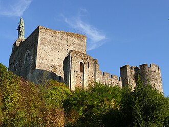
Photo : Forteresse de MontbazonPhoto : MOSSOT — CC BY-SA 3.0, via Wikimedia Commons
VisitesFacile

Forteresse de Montbazon

Cité historique par sa forteresse de l’an mil, Montbazon possède les atouts indispensables au bien-être de ses habitants et de ses visiteurs. Depuis son centre-ville rénové au pied de sa forteresse, les nombreux commerces offrent un choix appréciable de produits de qualité. Source : DATAtourisme.

14 min à pied
952 m de marche

Édifice remarquable
Illustration
SportDifficile

Arboretum de la Martinière

Le parc de quatre hectares est situé sur le site d'une carrière de sable dans la vallée de l'Indre à Veigné, en Touraine. Le parc est consacré aux arbres et aux arbustes de tous les continents. On y trouve aussi une centaine d'espèces de bambous qui poussent à merveille sur ce sol siliceux. Source : DATAtourisme.

49 min à pied
3,3 km de marche

Sport et loisirs
Illustration
RandonnéeDifficile

Sur les pas de Santiago Drake del Castillo

Ce parcours ombragé de trois kilomètres, au coeur d’un domaine classé « Espace naturel sensible », vous invite à découvrir un site romantique, aménagé vers 1855 par Santiago Drake del Castillo. Source : DATAtourisme.

88 min à pied
5,9 km de marche

Circuit à pied
Illustration
VisitesMoyen

Aurore - Domaine de la Tortinière

Château Hôtel Restaurant dans un grand parc, 32 chambres 4 étoiles, dominant l'Indre, aux portes de Tours, au coeur des châteaux de la Loire. Source : DATAtourisme.

34 min à pied
2,3 km de marche

Restaurant
Illustration
RandonnéeDifficile

A l'ombre des chênes centenaires

Le Domaine de Candé fut aménagé vers 1860 par Santiago Drake del Castillo, riche aristocrate anglocubain. La propriété, d’une superficie de 250 hectares, est aujourd’hui classée Espace Naturel Sensible grâce à la richesse de sa faune et de sa flore. Nous vous invitons à faire le tour du propriétaire Source : DATAtourisme.

88 min à pied
5,9 km de marche

Circuit à pied
Illustration
VisitesDifficile

Domaine de Candé

La boutique du domaine de Candé propose une large gamme de produits souvenirs : jeux enfants, cartes postales, livres pour petits et grands, jardinage, vin, gastronomie locale, boissons artisanales, bijoux créateurs... Source : DATAtourisme.

84 min à pied
5,6 km de marche

Dégustation
Illustration
RandonnéeDifficile

Le Montison

Au gré des terres agricoles et espaces boisés, découvrez le coteau sud de la commune de Monts. Source : DATAtourisme.

88 min à pied
5,9 km de marche

Circuit à pied
Illustration
RandonnéeDifficile

Les Belles Landes

Au gré des terres agricoles et espaces boisés, découvrez le coteau sud de la commune de Monts. Source : DATAtourisme.

88 min à pied
5,9 km de marche

Circuit à pied

Votre séjour commence ici.

Gardez ce camping et vos idées de sortie au même endroit.

VOTRE SÉJOUR, VOS CRITÈRES

Mes critères de déplacement

Aperçu avec ces critèresAperçu

01 · Ma marche confortable
200 m5 km
200 m6 km

Distance totale à pied sur un aller, y compris avant et après le bus.

02 · Mes transports confortables

Chaque changement de ligne compte comme une correspondance. Aucun intervalle entre bus n’est encore mesuré : il n’entre pas dans le niveau.

Mes limites « moyen » et ma durée de trajet

Jusqu’aux limites ci-dessous : « moyen ». Au-delà : « difficile ». Une limite moyenne reste toujours au moins égale à sa limite facile.

Mes essentiels et mes envies 3 besoins · 4 thèmes
Mes essentiels

Au moins un besoin. Chacun doit avoir sa propre adresse facile.

Mes envies de sorties

Au moins un thème. La difficulté d’une randonnée reste distincte de l’accès à son départ.